Scattered thunderstorms, damaging winds and dangerous heat loom for Kansas City area
Published in News & Features
KANSAS CITY, Mo. — A mix of summertime weather is expected in the Kansas City area in the coming days, ranging from the potential for scattered thunderstorms and dangerous heat, according to the National Weather Service.
“Widely scattered storms possible Friday through Sunday,” the weather service said in its forecast discussion. While organized severe weather is not expected, localized intense storms could produce “marginally large hail or damaging downburst winds.”
Hot and humid conditions will return to the metro area. Temperatures across the region will be in the upper 80s to lower 90s. In Kansas City, temperatures are expected to peak at around 92 degrees.
Typically, the metro sees temperatures around 89 degrees this time of year. Because of the humidity, it will feel more like the mid-90s.
Showers, thunderstorms in KC weekend forecast
There is a chance for thunderstorms on Saturday. Like Friday, organized severe weather is not expected, but a few strong thunderstorms are possible. Marginally severe hail and gusty winds are the main threats.
Temperatures will be slightly cooler on Saturday due to additional cloud cover and more widespread storms. Still, Kansas City temperatures are expected to rise to around 88 degrees. The heat value index is likely to be in the lower 90s.
Additional showers and storms are expected Saturday night into Sunday.
Temperatures will rebound on Sunday, rising into the low 90s. Heat index values are expected to be in the upper 90s.
Dangerous heat, extreme temperatures next week
It’s going to be extremely hot in Kansas City next week.
A heat dome setting up west of the Kansas City area is expected to bring dangerously hot temperatures to the metro area.
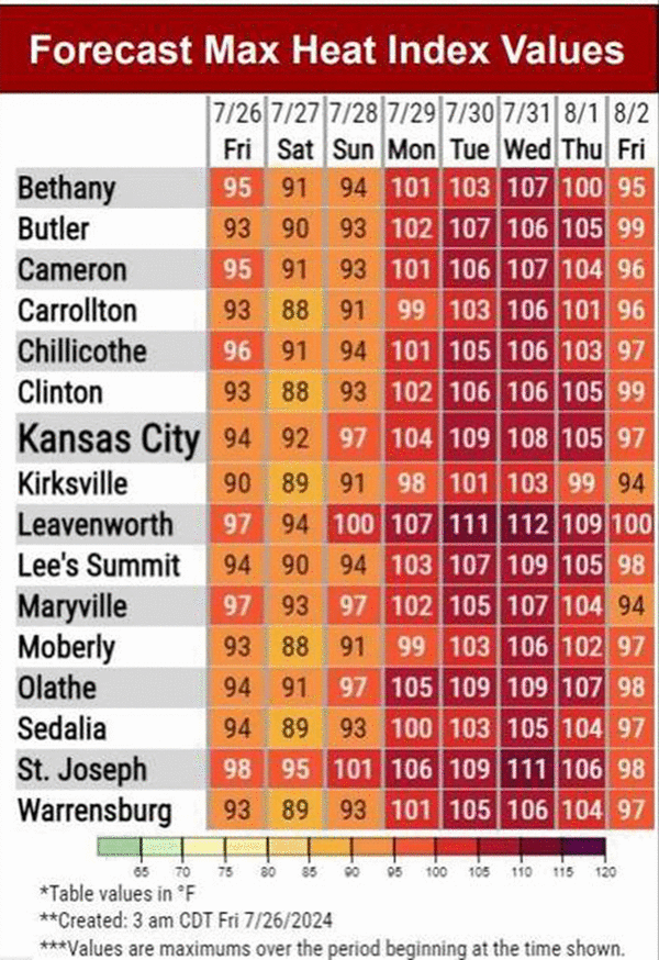
Temperatures are expected to be in the lower to mid-90s on Monday, the upper 90s on Tuesday and over 100 degrees on Wednesday. If temperatures get that hot, it will be the first time Kansas City climbs above 100 degrees this year.
“Dangerous heat possible next week,” the weather service said. “Forecast maximum heat index temperatures of 100 to 107F expected on Monday and increasing temperatures on Wednesday with max heat index temperatures of 103 to 112F.”
Kansas City saw a similar heat wave around this time last year. While heat index values, which were devised in 1979, are not kept as official records, they soared to record-setting levels last year, according to data from Iowa State University.
Kansas City’s heat value index reached 118.9 degrees on Aug. 21, 2023, breaking records just set in the two previous days — 118.1 degrees set on Aug. 20, 2023, and 117.2 degrees on Aug. 19, 2023, according to the data.
The weather service advises people to practice heat safety by staying hydrated, taking frequent breaks in shade and limiting strenuous activities outdoors. People should check on others without air conditioning and never leave kids and pets unattended in vehicles.
The extended forecast indicates that above-normal temperatures are likely for the first week of August. Precipitation will likely be below average.
©2024 The Kansas City Star. Visit at kansascity.com. Distributed by Tribune Content Agency, LLC.


Comments