Current News
/ArcaMax

UConn researchers determine potential cause of Alzheimer's disease. What to know
HARTFORD, Conn. — Researchers at the UConn Center on Aging have uncovered causal links between depression and Alzheimer’s disease and related dementia (ADRD), sparking hope for potential interventions to prevent the disease.
The Alzheimer’s Association found that more than 7 million people in the country live with ADRD.
Dr. Breno Diniz, ...Read more

NYC shooter was previously arrested at Las Vegas casino
LAS VEGAS — A Las Vegas man who killed four people in Manhattan on Monday had been arrested at Red Rock Resort two years earlier.
Shane Tamura was arrested on suspicion of trespassing at the Summerlin hotel and casino, according to a Metropolitan Police Department arrest report obtained Tuesday.
A police officer was called to the casino at ...Read more

Baited camera films one of 'the world's rarest shark species' off Wales
Off the western coast of the United Kingdom, conservationists attached some bait to an underwater camera, dropped the contraption to the seabed and waited. When they eventually watched the footage, it left them stunned.
They’d filmed one of “the world’s rarest shark species.”
A team of researchers set out to investigate “dolphin ...Read more

People who lived near 2 Pa. military bases had higher level of toxic compounds in blood than US average
Bucks and Montgomery County residents who live near military bases had higher levels of four “forever chemicals” known as PFAS in their blood than the typical American, according to federal health officials.
The chemical compounds are associated with higher levels of cholesterol, which is linked to increased risk of heart disease and stroke...Read more

Pa. Gov. Shapiro says 'protecting history' is crucial as Trump admin weighs removal of exhibits about slavery at Philly national park
Gov. Josh Shapiro took a stand Tuesday against President Donald Trump’s administration’s moves to review and potentially remove exhibits about slavery at Independence National Historical Park as part of an effort to restrict content at national parks that reflect negatively on the United States.
“Protecting our history is about telling ...Read more

U of M study: Wakeboats stir up lakebed sediments when operated in shallow water
Wakeboats in surfing mode should operate in at least 20 feet of water to avoid stirring up sediment in a way that’s harmful to water quality, according to a study by the University of Minnesota.
The study, made public Tuesday, found that wakeboats cruising at surf speed can trigger a complex set of waves that stir sediment. In turn, the motor...Read more

Sean 'Diddy' Combs makes another bid at bond ahead of sentencing
NEW YORK — Sean “Diddy” Combs is making yet another bid at bail as the Harlem-born mogul awaits sentencing his Oct. 3 sentencing on two prostitution-related charges.
Lawyers for the 55-year-old convicted Bad Boy Records founder, who was recently denied presentencing bail, argue that he should be released on $50 million bond and reside at ...Read more

Florida AG: Orange County must transport detainees to ICE facilities, or else
Florida Attorney General James Uthmeier is threatening to have Orange County commissioners and Mayor Jerry Demings removed from office if they don’t back down from their refusal to let corrections officers transport immigrants to federal detention facilities.
In a letter, Uthmeier accused the Orange County leaders of enacting “sanctuary” ...Read more

UCLA to pay $6.45 million to settle suit by Jewish students over pro-Palestinian protests
LOS ANGELES — UCLA will pay $6.45 million to settle a lawsuit stemming from pro-Palestinian protests in spring 2024.
The federal suit was brought by three Jewish students and a professor who alleged their civil rights were violated.
Much of the money will be donated to eight Jewish groups.
UCLA has agreed to pay $6.45 million to settle a ...Read more

Tighter security and grief hit Midtown Manhattan after shooting
Mere hours after a deadly shooting spree forced the evacuation of the 345 Park Ave. office tower in Midtown Manhattan, some employees came to collect their possessions.
As temperatures soared in New York City on Tuesday, they were asked to wait in the sun. The 44-story building — a symbol of the Wall Street North financial corridor home to ...Read more

FBI, National Guard assist St. Paul as cyber-attackers force shutdown of Internet-based systems
St. Paul Mayor Melvin Carter declared a state of local emergency on Tuesday following a days-long cyber attack on the city’s Internet-based computer networks that led the city to call in the FBI and Gov. Tim Walz to enlist the aid of the Minnesota National Guard’s cybersecurity experts.
The data breach has left officials in St. Paul city ...Read more

Trump EPA moves to eliminate landmark scientific rule that's the basis for climate regulations
The Trump administration’s U.S. Environmental Protection Agency proposed on Tuesday revoking a science-based determination that pollution fueling climate change harms public health. The so-called endangerment finding has for 16 years underpinned federal regulations for vehicles, power plants and other sources under the Clean Air Act.
EPA ...Read more

Trump says Russia has 10 more days to reach Ukraine truce
U.S. President Donald Trump said he would give Russia 10 more days from Tuesday to reach a truce with Ukraine, formally announcing a new deadline to pressure Vladimir Putin on ending the war.
“Ten days from today,” Trump told reporters aboard Air Force One on Tuesday as he returned to Washington from a five-day visit to Scotland.
Trump on...Read more

Park Avenue shooter Shane Tamura's claims put NFL's CTE problem in spotlight
NEW YORK — The NFL’s long history with CTE has come under new attention after Monday’s deadly shooting at the Manhattan office building that houses the league’s headquarters.
The gunman, identified as Shane Tamura, was said to be in possession of a note claiming he had CTE, a neurodegenerative disease, and that asked for his brain to be...Read more

NFL executive warned colleagues of NYC gunman after being shot in back, family says
NEW YORK — A brave NFL executive warned his colleagues there was an active shooter in their Park Avenue Midtown office building when he was shot and critically wounded in the lobby, his family told the Daily News.
“He was on his way home when he got shot,” wounded victim Craig Clementi’s father-in-law Robert Hunter said Tuesday morning....Read more
9-year-old girl identified after drowning death at Hersheypark
The 9-year-old girl who died at a water park in Hersheypark last week has been identified and her cause of death revealed.
Sophia Subedi died on Thursday while visiting The Boardwalk at Hersheypark, a family spokesperson told WGAL.
Subedi had been swimming in the wave pool when a lifeguard realized she was in distress and pulled her from the ...Read more

New York gunman, an LA high school football standout, left a note saying, 'Study my brain please'
Investigators are looking into whether a Las Vegas man who went on a deadly shooting rampage in Manhattan on Monday was targeting the National Football League after it emerged that the gunman was a Los Angeles high school football player with a documented mental health history.
New York Mayor Eric Adams said Tuesday that the shooter, identified...Read more

California, other states sue Trump administration over bill defunding Planned Parenthood
LOS ANGELES — California and a coalition of other liberal-led states sued the Trump administration Tuesday over a provision in the “Big Beautiful Bill” that bars Planned Parenthood and other large nonprofit abortion providers from receiving Medicaid funding for a host of unrelated health care services.
The measure has threatened clinics ...Read more

Florida has no formal hurricane plan for Alligator Alcatraz
MIAMI — After weeks of requests from politicians and media, the state of Florida said it has no formal, completed plan for how to handle a hurricane at Alligator Alcatraz, the new immigrant detention site in the heart of the Everglades.
Two weeks ago, the Miami Herald requested “the completed hurricane/disaster plan for Alligator Alcatraz�...Read more
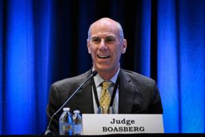
Justice Department hits judge in El Salvador deportation case with ethics complaint
WASHINGTON — The U.S. Justice Department filed an ethics complaint accusing a federal judge in Washington of making “improper” comments about President Donald Trump earlier this year, ratcheting up growing tensions between the executive and judicial branches.
The misconduct claim against U.S. District Chief Judge James Boasberg was ...Read more
Popular Stories
- Trump to set up Gaza 'food centers' to address 'real starvation'
- Republicans call Medicaid rife with fraudsters. This man sees no choice but to break the rules
- COVID rising in California. How bad will this summer be?
- New York gunman, an LA high school football standout, left a note saying, 'Study my brain please'
- 5 dead, including NYPD officer, in shooting at Park Avenue skyscraper housing Blackstone Group and NFL headquarters
Comics