Current News
/ArcaMax

Anwar's broken promises spark protests demanding his ouster
KUALA LUMPUR, Malaysia — When Anwar Ibrahim came to power in late 2022, it was with the promise of reform: cleaner government, a leaner budget and a break from the patronage politics that had defined his predecessors.
Nearly three years later, not much of that has happened. His plans for targeted subsidies and reduced public spending have ...Read more

RFK Jr. to oust advisory panel on cancer screenings, report says
Health and Human Services Secretary Robert F. Kennedy Jr. plans to oust members of the advisory board that decides which preventive health measures are covered by insurance, The Wall Street Journal reported Friday.
Kennedy is expected to remove the 16 members of the U.S. Preventive Services Task Force because he views them as “woke,” the ...Read more

One of the grenades recovered ahead of blast that killed 3 LA deputies is missing, authorities say
LOS ANGELES — One of the two hand grenades found in a Santa Monica townhome complex ahead of the deadly blast that killed three Los Angeles County sheriff’s detectives is currently missing, authorities said Friday.
The Bureau of Alcohol, Tobacco, Firearms and Explosives has determined that one of the two grenades detonated on July 18, “...Read more
News briefs
Trump picks Alina Habba to continue running New Jersey's US Attorney’s Office
WASHINGTON — President Donald Trump selected Alina Habba to continue running the U.S. Attorney’s Office in New Jersey on a temporary basis, the latest twist in a succession drama after federal judges had picked her top assistant to take her place.
Trump chose ...Read more

Police records in Idaho murder case: 5 things revealed about Bryan Kohberger
BOISE, Idaho — Hundreds of pages of documents released Wednesday by the Moscow Police Department after Bryan Kohberger’s sentencing hearing revealed some new information about the man who murdered four University of Idaho students.
Not much has been known about the personality of Kohberger, who sat through his plea hearing and sentencing ...Read more

Federal judge dismisses Trump administration lawsuit challenging Illinois, Chicago sanctuary policies
CHICAGO — A federal judge in Chicago on Friday blocked the Trump administration’s challenge to policies in the state of Illinois, the city of Chicago and Cook County that limit the powers of state and local police in assisting federal law enforcement on immigration-related matters.
The ruling comes as the Trump administration has ramped up ...Read more

Southwest flight from Burbank drops hundreds of feet to avoid possible collision
LOS ANGELES — A Southwest flight climbing away from Burbank Airport suddenly descended hundreds of feet Friday afternoon, possibly to avoid a mid-air collision.
The plane was at 14,100 feet above Angeles National Forest headed northeast to Las Vegas at 12:03 p.m. when it abruptly dropped to 13,625 feet, data from Flightradar24 showed.
The ...Read more

Maxwell and her Miami defense attorney in eye of Epstein storm. Trump, too
MIAMI — Miami defense attorney David O. Markus represents Jeffrey Epstein’s infamous former girlfriend, a convicted British socialite who may hold the keys not only to her fate but that of President Donald Trump.
Markus’ client, Ghislaine Maxwell, found guilty of recruiting underage girls for the billionaire financier, was questioned on ...Read more

Planned Parenthood clinics reel from Republicans' budget law
Several Planned Parenthood clinics are already closing after Republicans’ massive tax law immediately cut off Medicaid funds to the organization for one year.
Facilities in at least three states announced closures amid a challenging legislative and legal environment that came to a head after Congress banned organizations from receiving ...Read more

Trump birthright plan blocked as judge calls US case 'blasé'
President Donald Trump’s executive order limiting birthright citizenship was blocked nationwide for the third time in less than a month, the latest sign that a U.S. Supreme Court ruling restricting “universal injunctions” is having little impact on the dispute.
The injunctions set up another round of appeals that may ultimately be ...Read more

Chicago's federal judges approve appointment of Andrew Boutros as US attorney
CHICAGO — In a formerly rare move that’s a sign of unusual times at the Justice Department, a panel of federal judges in Chicago has approved Andrew Boutros’ appointment by the Trump administration as U.S. attorney in Chicago.
Boutros, 47, a former federal prosecutor, was selected by the Trump administration to serve in the powerful law ...Read more

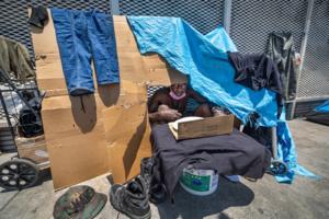
Minneapolis failed to take down a private homeless camp. Here's what happened
Minneapolis crews tried — and failed — Friday to take down a growing homeless encampment erected by a prominent property owner hoping to manage the problem himself.
After an hours-long standoff involving police officers, public works personnel and property owner Hamoudi Sabri, the city abandoned its efforts for the day, leaving the ...Read more

Florida DACA recipient released from Alligator Alcatraz, attorney says. He's still jailed
ORLANDO, Fla. — A Central Florida immigrant — who lives legally in the United States, according to his attorneys — has been released from the state’s Alligator Alcatraz detention center but remains in federal custody, his lawyer said Friday.
The man, who is a recipient of Deferred Action for Childhood Arrivals, or DACA, was arrested and...Read more

Trump won't rule out pardon for Ghislaine Maxwell amid Epstein investigation
President Donald Trump Friday refused to rule out pardoning Ghislaine Maxwell as the sex-trafficking accomplice of Jeffrey Epstein met for a second day with a top Justice Department official behind closed doors.
As he left the White House for a trip to Scotland, Trump dodged a reporter’s question about whether he was considering cutting short...Read more

ICE detains more than a dozen heading to work in Princeton, NJ
More than a dozen people were arrested and detained by ICE while they traveled to work in Princeton, New Jersey, local officials confirmed.
The operation occurred early Thursday morning with no notice or warning, Princeton’s local government said in a Facebook post. In total, 15 people without proper documents were taken into custody.
“...Read more

House Ethics panel releases findings on Alexandria Ocasio-Cortez, Mike Kelly
WASHINGTON — As lawmakers head into their summer recess, the House Ethics Committee wrapped up some longstanding business, announcing on Friday the results of its probes into Reps. Alexandria Ocasio-Cortez and Mike Kelly.
The committee concluded that Ocasio-Cortez, D-N.Y., impermissibly accepted gifts related to her appearance at the 2021 Met...Read more

Former New York Congressman George Santos reports to prison
Former Rep. George Santos surrendered to a federal prison in New Jersey on Friday to start an approximately seven-year sentence, after pleading guilty last year to wire fraud and aggravated identity theft.
Santos, who previously held a New York congressional seat as a Republican, started his prison term at FCI Fairton in New Jersey, according ...Read more
Criminalization or support? Trump's executive order on homelessness gets mixed reaction
An executive order signed by President Donald Trump purporting to protect Americans from “endemic vagrancy, disorderly behavior, sudden confrontations, and violent attacks” attributed to homelessness has left local officials and homeless advocates outraged over its harsh tone while also grasping for a hopeful message in its fine print.
The ...Read more

Tampa federal prosecutor fired by Pam Bondi files lawsuit over dismissal
TAMPA, Fla. — For almost a month after he was fired from his job as a Tampa federal prosecutor, Michael Gordon refrained from publicly commenting on his situation.
He stayed quiet even as word spread that his ouster was political retaliation for his involvement in prosecutions against those who stormed the U.S. Capitol on Jan. 6, 2021.
U.S. ...Read more

Homeless citations at Sacramento City Hall soar after Mayor McCarty takes office
SACRAMENTO, Calif. — As Sacramento leaders consider banning overnight sleeping at City Hall, police have already ramped up enforcement at the property under Mayor Kevin McCarty’s tenure.
In the past seven months, officers issued at least 187 citations to people sitting or lying at City Hall during the day. Only two such citations were ...Read more
Popular Stories
- A funeral home gave parents an unmarked box with their son's brain in it, lawsuit says
- Trump's homelessness crackdown direction draws pushback and some nods in California's Orange County
- Las Vegas police officer who fatally shot Brandon Durham will not be indicted, lawyer says
- 9-year-old dies after incident at Hersheypark's waterpark in Pa.
- Petition seeks to change new Kentucky law limiting teacher-student communication
Comics