Current News
/ArcaMax
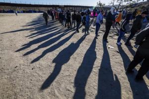
Seeking the elusive path for immigrants to legally come to US: 'People are dying in line'
LOS ANGELES — John Manley is sick of people telling immigrants to "stand in line" and "do it the right way."
An immigration attorney for almost three decades in Los Angeles, he said what most don't understand is that trying to legally come into the United States is nearly impossible for people from certain nations like Mexico.
"People are ...Read more

Giant pandas, tiger attacks and the ugly fight to control the San Francisco Zoo
Molting peacocks squawked in the distance and a Pacific breeze whispered through the eucalyptus as flamingo keeper Liz Gibbons tidied her station at the San Francisco Zoo.
It had been an unusually cold summer in a city famous for them. Marooned on "a breathtaking piece of land" at the peninsula's far western edge, steps from the deadly surf at ...Read more

Florida allowed capture of threatened giant manta ray for overseas aquarium
ORLANDO, Fla. — Denis Richard watched five men heave a giant manta ray from the waters off Panama City Beach and plop it into a pool on their boat deck.
“Let him go,” he yelled. “You ought to be ashamed of yourselves.”
Richard, a dolphin tour boat operator, was outraged that a threatened species often called the “angel of the sea�...Read more

California Democrats may target GOP congressional districts to counter Texas
LOS ANGELES — California Democrats led by Gov. Gavin Newsom may upend the state's mandate for independently drawn political districts as part of a brewing, national political brawl over the balance of power in Congress and the fate of the aggressive, right-wing agenda of President Donald Trump and the GOP.
The effort being considered by state...Read more

They are still discovering bodies in Altadena 6 months after fire. Are there other victims?
LOS ANGELES — While Katherine Alcantara was evacuating from her smoke-filled west Altadena home during January's firestorm, she remembered seeing her longtime neighbor returning home across the street.
In the chaos, she assumed he had come back to rescue his pets and grab some important belongings before heading to safety.
She never imagined...Read more

Anwar's broken promises spark protests demanding his ouster
KUALA LUMPUR, Malaysia — When Anwar Ibrahim came to power in late 2022, it was with the promise of reform: cleaner government, a leaner budget and a break from the patronage politics that had defined his predecessors.
Nearly three years later, not much of that has happened. His plans for targeted subsidies and reduced public spending have ...Read more

RFK Jr. to oust advisory panel on cancer screenings, report says
Health and Human Services Secretary Robert F. Kennedy Jr. plans to oust members of the advisory board that decides which preventive health measures are covered by insurance, The Wall Street Journal reported Friday.
Kennedy is expected to remove the 16 members of the U.S. Preventive Services Task Force because he views them as “woke,” the ...Read more

One of the grenades recovered ahead of blast that killed 3 LA deputies is missing, authorities say
LOS ANGELES — One of the two hand grenades found in a Santa Monica townhome complex ahead of the deadly blast that killed three Los Angeles County sheriff’s detectives is currently missing, authorities said Friday.
The Bureau of Alcohol, Tobacco, Firearms and Explosives has determined that one of the two grenades detonated on July 18, “...Read more
News briefs
Trump picks Alina Habba to continue running New Jersey's US Attorney’s Office
WASHINGTON — President Donald Trump selected Alina Habba to continue running the U.S. Attorney’s Office in New Jersey on a temporary basis, the latest twist in a succession drama after federal judges had picked her top assistant to take her place.
Trump chose ...Read more

Police records in Idaho murder case: 5 things revealed about Bryan Kohberger
BOISE, Idaho — Hundreds of pages of documents released Wednesday by the Moscow Police Department after Bryan Kohberger’s sentencing hearing revealed some new information about the man who murdered four University of Idaho students.
Not much has been known about the personality of Kohberger, who sat through his plea hearing and sentencing ...Read more

Federal judge dismisses Trump administration lawsuit challenging Illinois, Chicago sanctuary policies
CHICAGO — A federal judge in Chicago on Friday blocked the Trump administration’s challenge to policies in the state of Illinois, the city of Chicago and Cook County that limit the powers of state and local police in assisting federal law enforcement on immigration-related matters.
The ruling comes as the Trump administration has ramped up ...Read more

Southwest flight from Burbank drops hundreds of feet to avoid possible collision
LOS ANGELES — A Southwest flight climbing away from Burbank Airport suddenly descended hundreds of feet Friday afternoon, possibly to avoid a mid-air collision.
The plane was at 14,100 feet above Angeles National Forest headed northeast to Las Vegas at 12:03 p.m. when it abruptly dropped to 13,625 feet, data from Flightradar24 showed.
The ...Read more

Maxwell and her Miami defense attorney in eye of Epstein storm. Trump, too
MIAMI — Miami defense attorney David O. Markus represents Jeffrey Epstein’s infamous former girlfriend, a convicted British socialite who may hold the keys not only to her fate but that of President Donald Trump.
Markus’ client, Ghislaine Maxwell, found guilty of recruiting underage girls for the billionaire financier, was questioned on ...Read more

Planned Parenthood clinics reel from Republicans' budget law
Several Planned Parenthood clinics are already closing after Republicans’ massive tax law immediately cut off Medicaid funds to the organization for one year.
Facilities in at least three states announced closures amid a challenging legislative and legal environment that came to a head after Congress banned organizations from receiving ...Read more

Trump birthright plan blocked as judge calls US case 'blasé'
President Donald Trump’s executive order limiting birthright citizenship was blocked nationwide for the third time in less than a month, the latest sign that a U.S. Supreme Court ruling restricting “universal injunctions” is having little impact on the dispute.
The injunctions set up another round of appeals that may ultimately be ...Read more

Chicago's federal judges approve appointment of Andrew Boutros as US attorney
CHICAGO — In a formerly rare move that’s a sign of unusual times at the Justice Department, a panel of federal judges in Chicago has approved Andrew Boutros’ appointment by the Trump administration as U.S. attorney in Chicago.
Boutros, 47, a former federal prosecutor, was selected by the Trump administration to serve in the powerful law ...Read more

Minneapolis failed to take down a private homeless camp. Here's what happened
Minneapolis crews tried — and failed — Friday to take down a growing homeless encampment erected by a prominent property owner hoping to manage the problem himself.
After an hours-long standoff involving police officers, public works personnel and property owner Hamoudi Sabri, the city abandoned its efforts for the day, leaving the ...Read more

Florida DACA recipient released from Alligator Alcatraz, attorney says. He's still jailed
ORLANDO, Fla. — A Central Florida immigrant — who lives legally in the United States, according to his attorneys — has been released from the state’s Alligator Alcatraz detention center but remains in federal custody, his lawyer said Friday.
The man, who is a recipient of Deferred Action for Childhood Arrivals, or DACA, was arrested and...Read more
Trump won't rule out pardon for Ghislaine Maxwell amid Epstein investigation
President Donald Trump Friday refused to rule out pardoning Ghislaine Maxwell as the sex-trafficking accomplice of Jeffrey Epstein met for a second day with a top Justice Department official behind closed doors.
As he left the White House for a trip to Scotland, Trump dodged a reporter’s question about whether he was considering cutting short...Read more

ICE detains more than a dozen heading to work in Princeton, NJ
More than a dozen people were arrested and detained by ICE while they traveled to work in Princeton, New Jersey, local officials confirmed.
The operation occurred early Thursday morning with no notice or warning, Princeton’s local government said in a Facebook post. In total, 15 people without proper documents were taken into custody.
“...Read more
Popular Stories
- A funeral home gave parents an unmarked box with their son's brain in it, lawsuit says
- 9-year-old dies after incident at Hersheypark's waterpark in Pa.
- We combed through newly released FBI files on Martin Luther King Jr. Here's what we know
- DHS begins to fly detainees out of Alligator Alcatraz as DeSantis touts convenience of nearby airstrip
- Petition seeks to change new Kentucky law limiting teacher-student communication
Comics