Tropical Storm Beryl could form, approach Caribbean soon. Next system is right behind
Published in News & Features
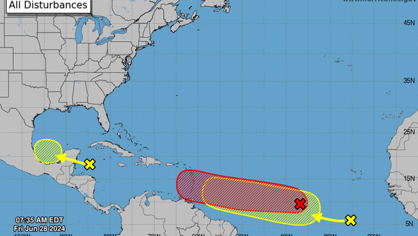
MIAMI — The Atlantic normally doesn’t get the conga-line look of tropical waves rolling off the African coast and heading west, one after the other, until the peak of the season. But on Friday, the National Hurricane Center was tracking one tropical wave that’s set to strengthen into Tropical Storm Beryl within the day, as well as another tropical wave right behind it.
As of 8 a.m., the hurricane center gave the initial wave a 90% chance of strengthening into a tropical depression or storm in the next two days. The next name on the list is Beryl.
“Showers and thunderstorms are also showing signs of organization, and a tropical depression or tropical storm will likely form later today or on Saturday,” the forecasters wrote.
The system was headed west at a fast clip — 15 to 20 mph — and was on track to approach the Windward Islands by Sunday. Forecasters warned residents of the islands to prepare for a storm, and tropical watches and warnings could be issued as soon as Friday evening.
From there, official predictions stop.
Global weather models, which are largely unreliable before a storm forms a solid center swirl, have suggested with some confidence that the system could keep heading west through the Caribbean until about Wednesday, before taking a fork in the road. A stronger storm could head north, models predict, while a weaker storm could continue to make a line drive toward Mexico and Central America, on the southern end of the basin.
“After five days, the models open up with very high uncertainty and a wide range of possible outcomes,” wrote Craig Setzer, chief meteorologist for Royal Caribbean Group, on Twitter.
“For now, the US Gulf Coast & Florida will have to keep a close eye on this system as it’s too early to tell what if any impacts there will be, but impacts can’t be ruled out for late next week/weekend.”
While much of the main development region of the Atlantic is clouded with hot, dry Saharan Dust — a notoriously un-storm-friendly feature — this system is set to form just south of the cloud, in a pocket of warmer-than-average water.
Hot sea surface temperatures are fuel for storms, and the Atlantic has plenty of that this year. So much so, that NOAA called it a primary reason the agency issued a season prediction for more storms than ever before.
The disturbance right behind the first one appears to be staying in the last dust-free, hot water lane.
As of 8 a.m., the hurricane center gave the tropical wave no chance of strengthening in the next two days, but a 20% shot at forming a tropical depression or storm in the next week.
“Some slow development of this system is possible next week while it moves generally westward across the central and western tropical Atlantic at 15 to 20 mph,” forecasters wrote.
©2024 Miami Herald. Visit at miamiherald.com. Distributed by Tribune Content Agency, LLC.


Comments